How big was Doha in 1947? What did my street look like in the 1950s, and did it even exist? How different was the Corniche in the 1960s?
Finding the answers to these questions became easier this week after researchers in Qatar launched a new, interactive map of Doha.

The online tool allows users to travel back in time and compare life in the capital city over the last eight decades to the present day.
The Doha Online Historical Atlas (DOHA) is the first in the Middle East to use state-of-the-art technology to create an intuitive, multi-media map of Qatar’s capital, and has been put together by a team from the University College of London Qatar (UCL Qatar).
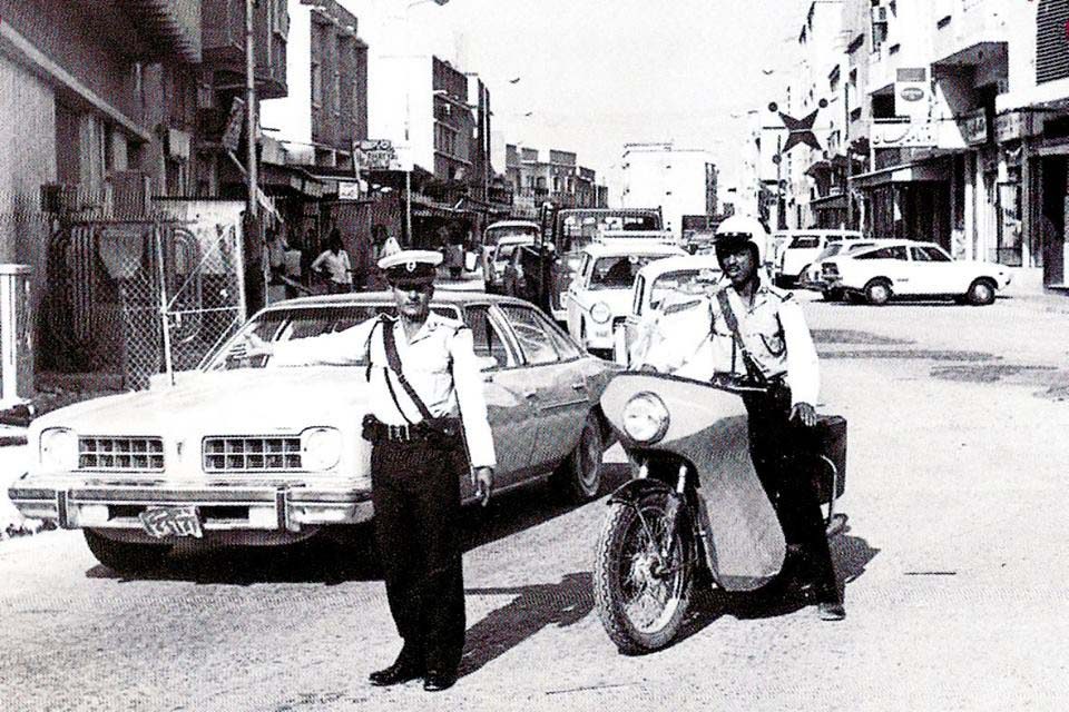
The map, which has been launched as a beta version, currently includes dozens of historical items, such as video footage from the 1960s showing city landmarks, 60 old photographs of places and people over the decades and 20 different aerial images.
While the majority of the material is from the 1940s-60s, there are also photographs dating back to the beginning of the century.

More material is due to be uploaded in the coming weeks and months, including around 20 clips of oral history of life in old Doha, taken from hours of interviews with Qatari citizens.
Mapping history
The team is also appealing to long-term residents to donate old photographs, video film, first-hand accounts and other items of historical importance that can be added to the map to build a richer picture of the rapidly changing face of Doha.
Material can be uploaded to the project’s dedicated crowdsourcing site.

On the launch day of the map, five photos of different parts of Doha from the 1980s, including early pictures of the Sheraton Hotel, an aerial view of Ras Abu Aboud flyover and old houses in Umm Ghuwailina, had already been donated.
Lead researcher Dr. Robert Carter, professor of Arabian and Middle Eastern archaeology at UCL Qatar, told Doha News that the tool was a first for the region and was experimental, but that he was optimistic of its success.
“There’s nothing like this in the Gulf, or even in Arabia. We already have a lot of material and more will be added, but we also want things people have lying around their house – family photos, videos – which show how Doha was back then,” he said.
The map is the culmination of nearly three years of work undertaken by the team as part of its Origins of Doha project, with the aim of showing not only how Doha has developed and expanded so rapidly over the decades, but also how this affected the everyday lives of people in the city at the time.
How it works
To map allows users to zoom in on a particular location, and overlap multiple maps from the decades to see how a district has changed its boundaries, streets and amenities such as mosques and shops.

Some areas such as Salata show dramatic transformation over the years, as what was once a neighborhood jutting into the peninsula has since become land-locked, due to land reclamation to build new districts and landmarks around it.
Aerial photographs can be overlaid onto the map, enabling viewers to enjoy a bird’s eye view of the rooftops from 60 years ago.
There are also detailed notes on archaeological sites and the old architecture of the city, such as the Nuaija well, just west of Najma Street, which was one of several clusters of wells dotted across Doha and which the population relied on for drinking water up until the 1950s.
Carter said that the aim of the project is not only to unlock some of the secrets of Doha’s history, but also to encourage people to connect more with the city’s heritage.
“We are trying to engage with Doha, which has moved so fast, and to capture the experiences of people who lived here at the time.
Through these maps and other documents, we want to lay down a historical pathway that gets people interested and involved in the city,” he added.
Project support
Funding for The Origins of Doha, which UCL has undertaken in collaboration with Qatar Museums, was through a $876,000 from Qatar Foundation‘s Qatar National Research Fund.
During the project, modern mapping techniques have been used to digitize early information and statistics about Doha, showing how the city has grown and changed.
Information such as the location of houses, mosques, wells and graveyards related to the communities around them have all been logged in a series of maps – partly to help researchers answer questions like why, for example, one large district only had one mosque, while another had four or five.

This is in addition to archaeological work undertaken in the oldest parts of Doha, around Souq Waqif and the Musheireb area by experts from UCL Qatar and Qatar Museums during late 2013.
Those digs aimed to reveal what everyday life in Doha was like in the 19th century. Among the items unearthed from a seven-acre site adjacent to the Fanar Islamic Cultural Center are keys, coins, jewelry, a dhow anchor and pottery estimated to be roughly 150 years old.
You can view the DOHA site here.
What are your memories of old Doha? Thoughts?


