Doha News juxtaposes satellite images of Gaza to show the extent of destruction due to Israeli attacks.
Ever since Israel started its relentless airstrikes on Gaza in the aftermath of the unprecedented October 7 attacks carried out by Hamas, nothing has been spared.
While international humanitarian law mandates against the targeting of civilians and civilian infrastructures, bombs have targeted residential complexes and tents, flattened schools and hospitals, as well as rendered entire neighbourhoods unlivable.
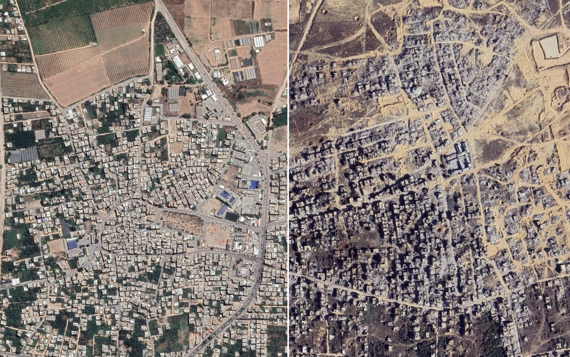
Beit Hanoun, a city in the northeastern edge of the besieged enclave, is one such. A visual investigation by The Guardian in January 2024, just four months into the now two-year-long war, concluded that virtually all of the city’s infrastructure was either destroyed or unsafe.
In addition to deaths and sweeping destruction, mass bombings have consequently resulted in the displacement of Palestinians within the besieged strip.
According to the United Nations Relief and Works Agency for Palestinian Refugees in the Near East (UNRWA), at least 1.9 million people — or about 90 per cent of the Gaza population — have been displaced to date.
Hence, hundreds of thousands have been forced to live under tent camps — like the one the newer satellite image shows below.
In a stadium named after 12-year-old Muhammad al-Durra, who was killed on the second day of the Second Intifada on September 30, 2000, thousands now live in makeshift camps.
Located in the central city of Deir al-Balah, the camp populated by those in search of a safe roof has continued to be targeted by Israel.
According to figures released by the United Nations Satellite Centre (UNOSAT) on September 27, at least 36,611 houses have been damaged in Gaza City alone.
Satellite images, albeit from December 2024, show the extent of sweeping damage across the capital of the Gaza Governorate.
Satellite images from the northern border of the coast also display the scale of damage.
In addition to civilian infrastructures, agricultural land as well as roads have been completely levelled in the north, while marks left by military vehicles and bomb craters can be seen in the latest images.
Airstrikes on the Jabalia refugee camps started a day after Israel declared “state of war” against Hamas. Shelling of the densely populated region located in the northeast of Gaza City has resulted in more than 900 deaths, with thousands injured.
While the images below are evidence of the magnitude of devastation in Khan Younis, Israeli bombs have continued to rain down on the southern city.
Satellite images from July 2025 (not shown below) recently revealed that the city has now been ‘almost completely levelled‘.
Just three months after taking full control of the Rafah crossing in May 2024, Israeli attacks flattened at least 44% of the infrastructure in its periphery.
Although Israel withdrew from the southern border crossing as part of the agreement in January 2025, it retook control on March 18 after it unilaterally ended the three-phase ceasefire following the first 42-day period.